 Nederlands
 Dansk
Dansk østerreichisch
 Po Polsku
 Italiano
 Francaise
 Portugiesisch
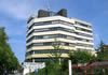


Gierswalde

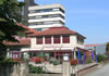
Gierswalde is situated in the Rehbach valley. The forest nearly touches the village, which is ideal for hikes on well developed trails and has lots of resting benches. Idyllic resting places and viewing points are located along the way. In the village is a fortification church from the 13th-century. There is also park and community centre with a reading room. Further leisure activities are guided hikes and bicycle tours as well as riding facilities. The national costume dancing group takes care of entertainment just as the many initiatives by the Solling club.
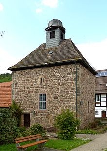
The chapel of Gierswalde is situated near the floodplain of the Reh beck. The chapel was probably constructed in the 14th-century. It has a soft rectangular layout and measures 9m by 6,85m, massive corner ashlar and a height of 8m up to the eaves. The red sandstone chapel has in its lower wall area a strength of maximum 1,45m, which reduce going up by alternating ledges at the narrow and long sides. In the inside are stone brackets in ca 1,5 metres height above the floor, which were used as roof beams holder. The choir window was designed in an arched closed style, above is an arched alcoves like a conch. The wooden barrel, which closes the church interior above, stems from later centuries. The chapel's outside walls are being sectioned by a few narrow wall loopholes. As the groundfloor is only 0,5m above the ground one assumes that the village green on which the chapel is situated had to be refilled to around 1m after floods. The same applies to the interior, which can be seen on the height of 1,5m of the brackets. For this reason the arched chapel door had to be raised.
A construction report to the consistory in Hanover from the year 1783 reveals that the present construction level is not that of the Gierswalde chapel. The upper walls had then a height of 24 and a half foot, which is converted roughly 8m, above this walls of the there situated half-timbered floor. If one assumes for this upper floor a height to 2m and takes into consideration the raised ground level through slurry the chapel must have had a tower of 11m height in earlier times. Work must have done already in the year 1659, as the date on the weather vane indicates. The chapel's east wall has a walled-in semi circular arch with the crest reaching nearly the ceiling of the former upper floor. The strong walls, the narrow wall gaps, the tower construction style and the location in the soggy Reh beck lowland as additional protection marks the chapel as a former fortification.


